ການຜະລິດພືດໃນອານາຄົດ ຂອງ ສປປ ລາວ (Telling story about the future of crops in Laos PDR)
")
ໃນໄລຍະເດືອນນີ້້ ກົມຄຸ້ມຄອງ ແລະ ພັດທະນາທີ່ດິນກະສິກຳ (DALAM) ໂດຍໄດ້ຮັບການສະໜັບສະໜູນຈາກອົງການອາຫານ ແລະ ການກະເສດ ແຫ່ງສະຫະປະຊາຊາດ (FAO), ອົງການສິ່ງແວລ້ອມໂລກ (GEF). ໂຄງການສ້າງຄວາມເຂັ້ມແຂງລະບົບຕິດຕາມ ແລະ ຂໍ້ມູນຂ່າວສານອຸຕຸກະເສດ (ຊາມິສ) ແມ່ນຈະໄດ້ເປີດການນຳໃຊ້ລະບົບຄຸ້ມຄອງຂໍ້ມູນຂ່າວສານຊັບພະຍາກອນດິນ (LRIMS) ຢ່າງເປັນທາງການໃນໄວໆນີ້.
ຫຼາຍຄົນອາດຄິດວ່າລະບົບ LRIMS ແມ່ນເປັນພຽງແຕ່ແຜນທີ່ເທົ່ານັ້ນ ແຕ່ໃນຄວາມເປັນຈິງແລ້ວ ກົມຄູ້ມຄອງ ແລະ ພັດທະນາທີ່ດິນກະສິກຳ ແລະ ສະຖາບັນຄົ້ນຄວ້າກະສິກກຳ, ປ່າໄມ້ ແລະ ພັດທະນາຊົນນະບົດ ໄດ້ພັດທະນາລະບົບທີ່ດີຂຶ້ນ ເຊິ່ງຊ່ວຍໃນການປະສົມປະສານແນວຄວາມຄິດ ແລະ ຂໍ້ມູນເຕັກນິກ ໃນການວາງແຜນວຽກງານກະສິກຳ. ບົດຮຽນໃນໄລຍະຜ່ານມາເຫັນໄດ້ວ່າ: ການເຂົ້າເຖິງ ແລະ ການນຳໃຊ້ຂໍ້ມູນທີ່ສ້າງຂຶ້ນໂດຍລັດຖະບານ ແລະ ພາກສ່ວນອື່ນໆ ແມ່ນຂ້ອນຂ້າງຍາກ, ນີ້ມັນສະແດງໃຫ້ເຫັນວ່າ: ພື້ນຖານສຳລັບການພັດທະ ນາ ແລະ ການສະໜອງເຄື່ອງມືຕ່າງໆ ໃນການເຊື່ອມໂຍງກັນລະຫວ່າງສູນຂໍ້ມູນດ້ວຍກັນ ຂ້ອນຂ້າງມີຈຳກັດ.
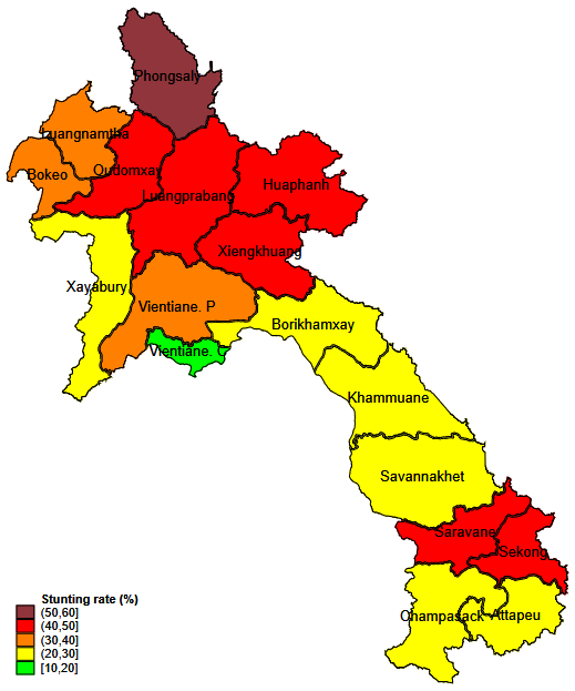
ການນຳໃຊ້ສະຖານະການຂອງຜົນຜະລິດພືດໃນອານາຄົດ, ໄດ້ມີການສ້າງແຜນທີ່ 2 ເລື່ອງຂຶ້ນ ຄື: ໜຶ່ງສຳ ລັບສາລີໃນອານາຄົດ ແລະ ອີກອັນໜຶ່ງສຳລັບອານາຄົດຂອງມັນຕົ້ນ. ແຜນທີ່ເຫຼົ່ານີ້ຈະຊ່ວຍໃຫ້ຜູ້ກຳນົດນະໂຍບາຍ ແລະ ນັກວາງແຜນ.
ການສ້າງແຜນທີ່ເລື່ອງໄດ້ຖືກນຳໃຊ້ເພື່ອກຳນົດເລື່ອງກ່ຽວກັບພືດບູລິມະສິດສະເພາະໃດໜຶ່ງ ເປັນການຈຳລອງຮູບແບບຂອງພືດ ໂດຍອີງໃສ່ການປ່ຽນແປງຂອງດິນ ແລະ ການປ່ຽນແປງຂອງສະພາບພູມອາກາດ.
ການສ້າງແຜນທີ່ເລື່ອງກຳນົດການຜະລິດພືດ ປະກອບດ້ວຍຂໍ້ມູນທີ່ຫຼາກຫຼາຍ ແລະ ແຕກຕ່າງກັນ ລະຫວ່າງປະຈຸບັນ ແລະ ອານາຄົດ ຫຼື ເປັນພືດເສດຖະກິດ. ນອກນັ້ນ, ຍັງເປັນການພັດທະນາຂອງຕ່ອງໂສ້ມູນຄ່າເພີ່ມຂອງພືດບາງຊະນິດ.
ແຜນທີ່ໆໄດ້ເຮັດມາຮອດປະຈຸບັນນີ້ແມ່ນສຳລັບ ສາລີກັບມັນຕົ້ນ. ຊຶ່ງສະຖາບັນຄົ້ນຄ້ວາກະສິກຳ, ປ່າໄມ້ ແລະ ພັດທະນາຊົນນະບົດ ແລະ ກົມຄຸ້ມຄອງ ແລະ ພັດທະນາດິນກະສິກຳ ແມ່ນໄດ້ຍື່ນປະຫວັດແຜນທີ່ນີ້ເພື່ອປຶກສາຫາລືນຳ ກົມນະໂຍບາຍ ແລະ ນິຕິກຳ. ກົມດັ່ງກ່າວແມ່ນຈະໄດ້ທົດລອງນຳໃຊ້ປະຫັວດແຜນທີ່ນີ້ ກັບບັນດາແຂວງທີ່ປູກພືດດັ່ງກ່າວນີ້. ບັນດານັກຊ່ຽວຊານ (ນັກວິຊາການ ຈາກພາກລັດ ແລະ ເອກະຊົນ) ຈາກບັນດາແຂວງດັ່ງກ່າວ ຈະສົມທົບກັບບັນດາຊ່ຽວຊານດ້ານເຕັກນິກຢູ່ສູນກາງ ເພື່ອປັບປຸງ, ໃຫ້ຄຳຄິດເຫັນ ຫຼື ປັບແກ້ ປະຫວັດແຜນທີ່ດັ່ງກ່າວ. ເນື່ອງຈາກການລະບາດຂອງພະຍາດໂຄວິດ-19, ການລົງພື້ນທີ່ຕົວຈິງໄດ້ເລື່ອນໄປ ແລະ ອາດຈະໄດ້ຈັດຕັ້ງປະຕິບັດໃນໄວໆນີ້.
ປະຈຸບັນນີ້້ ສະຖາບັນຄົ້ນຄ້ວາກະສິກຳ, ປ່າໄມ້ ແລະ ພັດທະນາຊົນນະບົດ ແລະ ກົມຄຸ້ມຄອງ ແລະ ພັດທະນາດິນກະສິກຳ ແມ່ນໄດ້ເລີ່ມສ້າງປະຫວັດແຜນທີ່ສຳລັບ ກ້ວຍ ແລະ ກາເຟ.
This month, the Department of Agricultural Land Management (DALAM), with the support of the FAO/GEF project Strengthening Agro-climatic Monitoring and Information System (SAMIS), will make the Land Resources Information Management System (LRMIS) public.
One might think that the LRMIS is only about maps. Instead, DALAM and NAFRI went onward to develop a better system that help about an harmonized thinking on the agricultural planning. Often, in the past, it is quite difficult to access and use the data produced by the government or by other entities. This was due to either poor of data platform nor linkage among data hub.
Using scenarios of crop productivity in the future, two storymaps have been produced, one for the future of maize, and one for the future of cassava. These storymaps will help policy makers and planners .
Story mapping gives a way of thinking about a specific issue from the perspective of multiple stakeholders. This is facilitated by defining so called “user stories” that describe the experience of viling in a certain scenarios. In conjunction with SAMIS data, story maps are used here to define the story of certain priority crops. This means we try to make a scenario depending on certain soil and climate change modifications.
This is supported by GIS and crop experts, that help preparing the data. The story maps contains different information. First, the experts obtain the problems that a certain crops will likely have, then maps of difference between the crops today and tomorrow. This allow to see where a certain crop will not be economically sustainable in the future. Also, the barrier for a further development of the value chain of a certain crop.
The story maps produced so far relates to cassava and maize. NAFRI and DALAM will now submit the storymap for discussion to the Department of Policy and Legal Affairs (DoPLA). The Department will pilot the storymaps in provinces where the two crops are growth. The experts (civil society, private sector, government technicians) of these location will interact with technical experts from central offices to improve, comment, or modify the storymaps. Due to covid, the field missions were postponed and will be done at soonest.
At the moment, the work are started at DALAM and NAFRI for banana and coffee. The work is guided and supervised by the Utrecht of Utrecht in Netherlands